Highlights
- Immersive View for Routes: Get a 3D preview of your journey with real-time data
- Photo-First Search Results: Discover new places with visual search capabilities
- Lens in Maps: Use augmented reality for real-time navigation and surroundings info
- Enhanced Driving Navigation: Improved lane guidance and HOV lane support for safer trips
Google Maps, the go-to navigation app for millions worldwide, has just unleashed a game-changing update.
Packed with cutting-edge AI technology, these new features are set to transform how we navigate our world.
From immersive 3D views to smarter search capabilities, Google is pushing the boundaries of what’s possible in digital mapping.
Let’s dive into the five groundbreaking features that are making waves in the navigation world:
Immersive View for Routes: A Virtual Preview of Your Journey
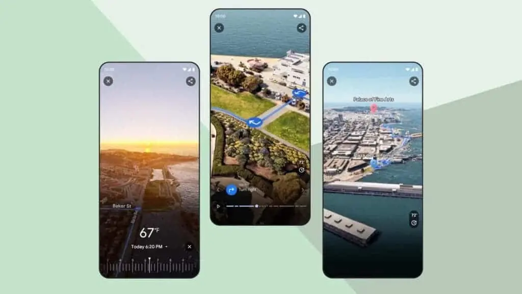
Imagine being able to fly over your route before you even step out the door.
That’s exactly what Immersive View for Routes offers.
This feature combines Street View imagery, aerial photos, and real-time data to create a lifelike 3D preview of your journey.
Whether you’re navigating the bustling streets of New York or the winding canals of Venice, you can now get a bird’s-eye view of your entire route.
The system even simulates weather conditions and traffic patterns based on historical data, giving you a realistic expectation of what lies ahead.
This feature is currently rolling out in 15 major cities, including London, Paris, Tokyo, and San Francisco.
It’s not just a visual treat – it’s a powerful tool for planning and decision-making, allowing users to familiarize themselves with complex routes before embarking on their journey.
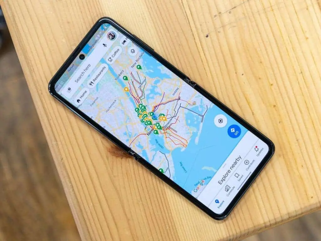
Photo-First Search Results: A Visual Feast for Explorers
Google Maps’ search function has received a major upgrade.
Now, when you search for specific places or experiences, the app delivers photo-first results drawn from billions of user-shared images.
Looking for a café with intricate latte art?
Or perhaps a scenic viewpoint for sunset photography?
Simply type in your query, and Google Maps will present you with a gallery of relevant, eye-catching photos.
This visual approach to search makes it easier than ever to discover new places and experiences that match your interests.
Lens in Maps: Augmented Reality at Your Fingertips
The app’s AR capabilities have been enhanced with the introduction of ‘Lens in Maps’ (formerly known as ‘Search with Live View’).
This feature turns your phone’s camera into a powerful tool for understanding your surroundings.
By tapping the ‘Lens’ icon in the search bar, you can access a live camera view that labels nearby buildings, landmarks, restaurants, and more.
It’s like having a knowledgeable local guide in your pocket, helping you identify and navigate your surroundings with ease.
This feature is particularly useful for travelers in unfamiliar cities, or for anyone looking to quickly orient themselves in a new area.
Enhanced Driving Navigation: Safer and Smoother Journeys
For those behind the wheel, Google Maps now offers a more detailed and realistic navigation experience.
The update includes improved lane guidance, more accurate building representations, and the addition of High-Occupancy Vehicle (HOV) lanes in applicable areas.
These enhancements are designed to help drivers navigate complex intersections and busy highways with greater confidence.
By providing a more accurate representation of the road ahead, Google Maps aims to reduce driver stress and improve overall road safety.
While the exact rollout timeline is still unclear, these improvements are expected to become available in 12 countries, including the United States, Canada, France, and Germany, in the coming months.
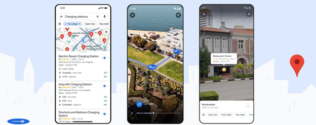
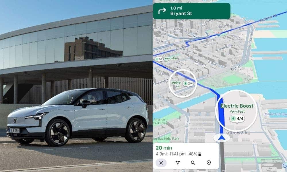
Smarter EV Charging Information: A Boon for Electric Vehicle Owners
Electric vehicle (EV) owners will find the latest Google Maps update particularly useful.
The app now provides more comprehensive information about charging stations, including compatibility with specific vehicle models, charging speeds, and recent usage data.
This feature addresses a common pain point for EV drivers – the uncertainty of finding a functional and compatible charging station.
With reports suggesting that up to 25% of EV chargers in the US may be out of order at any given time, this update could significantly reduce the stress of planning longer journeys in electric vehicles.
A New Era of Intelligent Navigation
These five AI-powered features represent a significant leap forward in navigation technology.
By harnessing the power of artificial intelligence, Google Maps is not just showing us the way – it’s providing a richer, more interactive, and more informative journey experience.
From virtual 3D previews of our routes to AR-enhanced exploration of our surroundings, these updates make navigation more intuitive and user-friendly than ever before.
They cater to a wide range of users, from pedestrians exploring new cities to drivers navigating complex highways, and even EV owners planning their next charging stop.
FAQs
What is the Immersive View for Routes feature in Google Maps?
Immersive View for Routes provides a 3D preview of your journey, combining Street View imagery, aerial photos, and real-time data to help you plan your route effectively.
How does the Photo-First Search Results feature work in Google Maps?
When you search for places or experiences, Google Maps now shows photo-first results from user-shared images, making it easier to find locations that match your interests visually.
What is Lens in Maps, and how can it help me?
Lens in Maps uses augmented reality to label nearby buildings, landmarks, restaurants, and more through your phone’s camera, making it easier to navigate and understand your surroundings.
What improvements does the Enhanced Driving Navigation feature bring?
Enhanced Driving Navigation offers better lane guidance, accurate building representations, and HOV lane support, aiming to reduce driver stress and improve road safety.
How does Google Maps assist electric vehicle owners with charging information?
Google Maps now provides detailed information about EV charging stations, including compatibility with specific vehicle models, charging speeds, and recent usage data, helping EV owners find reliable charging points.
Also Read: Google Maps to Introduce Group Navigation with AI-Powered Route Planning
Read More: Google Pay in collaboration with Pine Lab starts Tap to Pay for UPI in India
Also Read: Google Maps for Android Now Features Real-Time Weather and AQI Updates